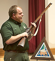
 Missouri Department of Conservation Outdoors Skills Specialist Brian Flowers shows off a shotgun historically known as a fowling piece that he said was similar to the one Missouri "explorers" Henry Rowe Schoolcraft and Levi Pettibone mistakingly thought they could use to kill large game.
by Mari Winn Taylor
In the winter of 1818-1819 two men from upstate New York set off on a 900-mile trek through territory that eventually became part of the state of Missouri. Henry Rowe Schoolcraft and his companion Levi Pettibone have been dubbed by some the "Louis and Clark of Missouri." We know of Missouri's early flora and fauna through the eyes of Schoolcraft because of a journal he wrote in part entitled, Journal of a Tour into the Interior of Missouri and Arkansaw, giving credit to those academians like Milton D. Rafferty, MSU professor emeritus, who made sure it and Schoolcraft's other writings remained in print.
If you've been to Smallin Cave in Ozark you would know that one of the first items on the path to the cave is a plaque dedicated to Schoolcraft for his presence in the area. (An Easterner, I know of an abundance of signage that "George Washington slept here"--Washington was credited for doing more sleeping than in his capacity as general. Schoolcraft apparently was credited for having "walked through" places, although we do find out that in many instances he and Pettibone were simply lost.)
Not being a Missouri historian, I have to admit that I was not privy to the significance of the name "Schoolcraft." So, I was delighted to attend the program about the man at the Springfield Conservation Nature Center on April 7, 2016. The 90-minute event was divided into three parts: how a celebration of Schoolcraft came about, and how who he was and what he observed differs from what may be found today, including comments from members of the Missouri Department of Conservation who attempted to compare the then and now of topography in what became Missouri.

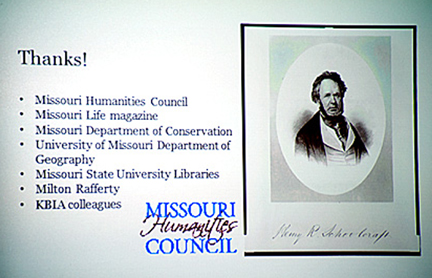
Motivation to contribute to the 200th year bicentennial of the Schoolcraft Expedition can be attributed to Trevor Harris, pictured at right, producer/host of the University of Missouri's NPR station, KBIA. and his "Thinking Out Loud Show." Thanks to a $4,000 grant from the Missouri Humanities Council and support from Missouri Life magazine Harris and his KBIA colleagues have created a series, "The Landscapes of Henry Rowe Schoolcraft." They also have generated interest for Schoolcraft's travels by interviewing people along the route which began and ended in the galena rich area settled by Moses Austin that is now called Potosi. (The route that Schoolcraft and Pettibone took has been preserved on a map that was a nice hand-out to those who attended the program. Not only does it show the route traveled but it also designates camp sites and illustrates the topography found.)
We are told that Schoolcraft leaves his sophisticated village-oriented life after his position at a family-run glass factory is terminated presumably because of a bad economy. Having studied mineralogy, Schoolcraft decides to head west with grandiose ideas of attaining a lucrative position with the government--federal superintendent of the Missouri lead district. Armed with the overconfidence that youthful nerve brings (he was 25), and lacking hunting skills, he and Pettibone, the brother of his bankruptcy lawyer, make the daring exploration to the Ozark Mountains beyond the line of settlement. (Interestingly, that while the suggestion was made that Schoolcraft was the motivator for the trip, I found,--perhaps, unsubstaniated--a website that gave much more credit to Pettibone. See it here.)

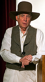
Playing the role of Schoolcraft was Bob Kipfer, pictured at left, a member of the Springfield Plateau Chapter of the Missouri Master Naturalists, a retired Ferrell-Duncan physician and owner/preserver of a 400-acre tract of forest and prairie near Bull Creek. Trying to keep his reenactment from being too awkward, Kipfer read mostly from schoolcraft's journal. We learn about how the travelers lose equipment, including gunpowder, because the clear streams they crossed were deeper than they thought. No wonder their pack horse named Butcher ran off a couple of times. At one point in their journey, as noted on the map about one month after they started out, the travelers "starving and lost, abandoned their horses and gear and searched south for settlers' help." We even find out that once lost they used the instincts of their horses to lead them back to town. Interestingly, wildlife was abundant and Schoolcraft in his journal detailed this, cataloguing bear, deer, elk, beaver, wild turkeys, prairie hens, swans, ducks, geese and wolves, that, one would think, would provide enough food for anyone's survival.
In spite of this obvious naivete (by the way, they were lucky to find empty Osage camps for use), Schoolcraft's attitude towards the locals at least initially was incredibly superior. He was judging the locals through a "more civilized lens."It was true that the hunters and their families lived crudely and were illiterate, but their survival instincts were definitely beyond comparison. (By the way, in 1853 when Schoolcraft, 60, wrote a sequel, it was with an entirely different manner of thinking.)
Missouri Department of Conservation speakers
The final segment of the program conducted by two members of the Missouri Department of Conservation dealt with the change in natural environments. John George, a natural history biologist entrusted with restoring prairies and other natural communities, told how the Indians set fire to the prairies as a reason for why Schoolcraft used the term "barren" to describe much of the landscape. He found damaged trees, a lack of cedar and grasses becoming more abundant. George described how the southwest side of a slope is more affected by fire and would appear more barren as opposed to the timbered northeast side. Glades were also common in the Ozarks, George said, and Schoolcraft would have described this area also as "barren."
Through the years, George noted how the concept of land management in Missouri has changed--from the reduction of savannas to the creation of forests to bringing back less dense areas and the encouragement of the growth of woodland flowers.
The role of Brian Flowers, the MDC outdoor skills specialist, is to connect Missourians with state resources. He told how he was especially connected to Schoolcraft in the book edited by Rafferty. He walked Schoolcraft's route with a group of teachers, hoping to create an immersive experience that they would bring back to their classrooms. Flowers walked where he was born--including an area north of Ashley Creek, land overlooking the Big Piney and Little Piney rivers, land in Dent County and the Indian Trail Natural Area. An area described by Schoolcraft as a "desolate place" was now woody, Flowers said, but angular stones that the journal writer describes, of course are still there. Flowers and his group were thrilled to be able to walk in Schoolcraft's footsteps.

--photos by Vince Rosati


Comments